Thursday, 4 December 2014

Autumn Colours 2014

Well another autumn has passed and the trees are mostly bare now save for a few stubborn leaves hanging on. 

Like every year the anticipation for photographing autumn colours begins to build as September comes to an end.  A few very cold mornings coupled with the shorter days and the trees soon begin to turn.  Unfortunately this year started off well, but in Teesdale, a warm band of air, coupled with strong winds and heavy rain soon put paid to any thoughts of capturing an exceptionally colourful year.  

Add in the better part of another 3 weeks lost to back problems, which meant the high mountains were out and things became a tad frustrating.  Still there are always easy walks to help keep the spirit up.  

Teesdale


 The Tees at Low Force in very low flow conditions.  The trees were starting to look good by the middle of October

The south side of Low Force


Wynch Bridge


 A few days later and strong winds and heavy rain soon stripped the leaves from the trees.   Bowlees Beck and Summerhill Force

Summerhill Force and Gibson's Cave

Shorter days coupled with the clocks going back meant plenty of opportunity for shots captured in the dark.  


The falls just above Low Force captured as darkness fell.


Captured a little further upstream in complete darkness.  Don't forget your torch

Lake District
A couple from a grey wet weekend in the Lakes
Lanty's Tarn
  
Clearing skies over Brothers Water 


All images and text copyright David Forster www.bluestoneimages.com 

Wednesday, 26 November 2014

Satmap Active 12 Review


Satmap Active 12 - Cost including full UK 1:50K mapping £400.00 Current retail price around £450.00


I bought this Satmap Active 12 prior to release as part of the Beta Testing program in November 2013.

Buying Experience
I got the Satmap 12 from Above and Beyond and found the buying process was good.  I have to say however, I was not too happy about the fact they took payment from my credit card before they got the unit in stock.  In fact I received my credit card bill with the unit on it well before delivery!
First Impressions
To start with my experience was not good due to the fact it had to go back twice when the update process caused a fatal issue with the unit.  Satmap however were quick to deal with the problem. 

This incidentally brings me to the subject of Beta testing.  At no stage was I asked for an opinion about the unit, nor was any form of verbal, or written feedback requested.  In reality Beta testing for me simply meant buying a GPS with unfinished software on it and then uploading updates as they became available.  

Review based on 1 year of regular use since November 2013
The first thing I need to say is I am no GPS expert and I actually enjoy map reading using paper maps and as such have resisted using GPS mapping software for years.  That said I do a lot of mountain walking on my own, very often in the dark, either when heading up a mountain to catch the early morning light, or indeed, heading down in the dark after a sunset.  I therefore got the Satmap 12 to make life that little bit easier and to use as a backup for the inevitable navigation difficulties (ok cock ups) I sometimes experience when navigating in the mountains at night. 

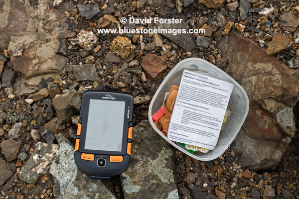
The unit has also been used for the odd Geocache and for road/mountain biking.


Hunting down the odd Geocache was a good way to get to know the unit

In Use
On the whole it is a decent piece of kit, although there are several niggles.

For example in anything bordering on wet weather damp easily gets between screen protector and the screen itself, which obviously affects viewing the unit.  Removing the protective screen is not that easy in the field so you either put up with it, or remove the protector altogether and then risk scratching the screen.  It is not a serious issue as far as reading the mapping goes, but does mean you have to remove the cover at some stage to ensure the screen has dried out.  The unit of course is only weather resistant, not waterproof, but even so if the screen cover joint is hit by a few drops it becomes a problem. It can also be an issue in damp misty conditions as well.  If it bothers you too much then a separate protective case can be purchased at additional cost.

Another associated problem is that dust and other debris can easily get between the screen protector and the screen.  This really hacks me off as I find it distracting in certain light conditions.  Would it really have been so difficult and expensive to add a seal?

The unit comes supplied with a rechargeable battery unit and a separate battery carrier, in which you can add 3AA batteries should the rechargeable battery become discharged.  One of the concerns I have with the plugging and unplugging of each battery pack is that the plug is so tiny you end up pulling on the wires rather than the plug.  It is also rather fiddly and a complete pain when it is cold and windy.  Why a simpler click system, similar to say a camera, or mobile phone was not used I don't know. 

Charging/Download cable
This has a 90-degree bend at the Satmap end of the plug and is of very poor quality and has already split.  I do not incidentally unplug it by pulling on the cable itself. To deal with this I have simply swapped it for a cable with a straight plug.  

On the subject of charging, the unit also switches on and goes through the full boot process when you plug in the charger instead of simply charging the unit.  I got caught out the first time when I simply put the unit away after charging only to find out the battery was flat when I came to use it.     

Having read a number of magazine reviews, many of which appear to have been written quite soon after the release, it amazes me that nobody has mentioned some of these niggles.  Actually no it doesn't, using something for a couple of weeks is not really a review is it.

Unit Operation
The OS mapping software comes on SD card which simply clicks into the side of the unit.  The clarity of the High-Resolution HVGA screen is excellent.  A pal of mine has the  Active10 and there is a clear improvement here. 

Using the large orange buttons to navigate the various menus is pretty straight-forward and fairly intuitive once you understand the terminology.

The unit is also relatively quick to boot up, load mapping from the card and find satellites (average 2-4 minutes).  This does appear to be an improvement when compared to the Active 10 a friend of mine has.

One slight negative is that sometimes the software seems to run very slowly for no identifiable reason and navigating around the map can be frustrating when you move the joystick, but the map hardly scrolls.  Tiling is also quite bad when this happens.  That said I use this unit week in week out and it has not become a serious issue for me.  I assume this will be resolved in future software upgrades.

Testing Limitations
I only use a fraction of the functions available on this unit and therefore cannot comment on such things as paperless geocaching, detailed route planning, barometric elevation, bluetooth and peer-to-peer sharing for example.


My experience of the mapping software is limited to the OS 1:50,000 maps.

I have yet to try updating the software and as I mentioned earlier I did have some serious issues with the upgrade process during beta testing and the unit had to go back twice.  However this was using a different "Light" update process to the Satsync process users now go through and I was assured this would no longer pose a problem. 

In Short
Pros

  • The high res screen also means I don't have to keep putting reading glasses on to see the detail.
  • Orange buttons are easy to see in the dark and fairly easy to use with gloves that are not too bulky
  • Software and mapping fairly straight forward to operate
  • Additional mapping such as OS 1:25K is available on SD cards
  • Rechargeable battery life is good and once discharged it is possible to replace this with 3 AA standard, or Lithium batteries using a separate carrier (supplied with the unit)
  • Compass can be calibrated for use on a bike.
Cons

  • Relatively high cost of unit
  • Additional mapping seems expensive.
  • Changing the battery carrier is a pain due to the tiny plug and you end up pulling on the wires.
  • Screen protector is poorly designed and allows dust, damp and water between it and the screen.
  • Design of the charging/power cable is poor quality and design
  • The unit also switches on and goes through the full boot process when charging instead of simply charging the unit. 

All said I think this is a decent unit and the positives certainly outweigh any negatives.

Rating 4 out of 5


Important information for those new to mountain navigation.
If you are new to walking, especially in a mountain environment, it is important to recognise a GPS unit of any kind is not a replacement for a paper map and compass, along with the ability to navigate using them.

Batteries will discharge quicker in cold weather and you need to carry spares.

If only using the 1:50 mapping software that comes with the unit as standard, a lot of detail such as steep ground and crags for example will not necessarily be obvious.

Regardless of the mapping just like a paper map you still need the ability to read map contours, recognise slope aspect and be able to plan your route, taking into consideration your speed and the fact you may need to navigate around hazards rather than walk on straight A to B bearings to reach your objective.

Text/imagery copyright David Forster www.bluestoneimages.com

Friday, 31 October 2014

Harris Lewis and Beyond Pt 2

Northern Scotland

By the time we had made it from the Isle of Harris/Lewis to Durness we only had 3 days left for actual walks, and as the weather was set to remain rather Scottish with heavy showers and yet more gale force winds, we again decided to stick with the beach holiday theme.  

Arriving in Durness just after midday we headed straight for the Sango Sands campsite which is set on the edge of the cliffs above Sango Bay.  


Campervans overlooking the beach

After lunch we headed off for a short walk that involved a visit to Smoo cave.  Having spent my youth caving in the Yorkshire Dales, I tend to avoid cave tours, especially if I have to pay.  That said I really did enjoy this little trip and the guy taking us down really knew his stuff. It's only a short trip of around 20 minutes and if you have never been down a cave it would be a good introduction.  You can of course still go into the cave without paying, it's just the cave accessed by boat that you pay £4.00 for.  More info in the links below


You can see a quick video of the trip here, or click on the link to watch in another window 


Apologies for my web address appearing throughout the video but a promotion company nicked parts of my Iceland video off YouTube and used it to promote a car hire business.

Balnakeil Bay and Faraid Head
Next morning was clear so I headed down to the bay just before sunrise.  I wasn't alone in my quest for capturing some nice light and another photographer from Ireland was already setting up further along the beach.  It was a bit difficult trying to keep out of each other's shots, but even so we both managed to capture some people free images. 


Sango Bay

After breakfast we walked around to Balnakeil Bay to enjoy a circular walk up onto Faraid Head, returning along the eastern headland.  

Balnakeil Bay is easily accessible and is a short walk I have done numerous times.  Each time there is always something interesting to see or photograph and today was no different.


While messing about photographing shells and crabs we came across a Dolphin stranded on the beach about 20 metres into the sea.  On the access to most beaches up here there are signs with phone numbers for the Scottish Marine Animal Stranding Scheme.  Typically we did not have the number with us, but fortunately while we were discussing whether to head back along the beach to get it, a couple of their members turned up.  They told us the person who had called them had also spotted a young dolphin in difficulty as well.  The guys waded into the sea to check, but sadly there was nothing that could be done for the adult and as the young dolphin appeared to have headed back into the bay, they dragged the dead animal ashore.


Leaving the rescuers waiting for someone to come and do an autopsy we continued our walk, eventually coming across another dolphin that had been found alive a week or so ago.  Again little could be done for it and it was put down to end its suffering.


Whether it was the storms, illness, pollution, or indeed a combination of these factors it was hard to say, but it was at least heartening to know that there are groups of people around our coast collecting data in order to understand the problems facing marine animals. More info via the link.


Leaving the beach we headed out onto Faraid Head and spotted a seal close to the shore.  A few minutes later we spotted what we thought was another dolphin in trouble.  It was too far off to photograph, but a look through the binoculars showed it was actually a dead cow floating in the sea!  


 Faraid Head

 The view from Faraid Head across Balnakeil Bay. More rain on the way.


Sandwood Bay
Sandwood Bay, or to give it its Viking name Sandvatn (Sand and Water) has a lot of myth, legend and folklore associated with it.  Stories of beautiful mermaids, ship wrecks and the ghostly wanderings of lost sailors all come together in this wild and remote setting.  It is one of those beaches that any lover of wild places should visit at least once in their lives and for me it is perhaps the best beach walk in the UK, it's certainly one I cannot help returning to. 

On reaching the remains of Sandwood Lodge we got our first view of the beach and could see the tide was almost fully in.  Despite still being at least a kilometer away, we could hear the constant rumble of large waves pounding the shoreline. 


On the beach itself any ideas of wandering barefoot along the tide line were soon quashed.  In fact due to the sloping nature of the beach it was pretty dodgy walking 20 or thirty feet above it due to the fact some of the larger waves would race up the sand way beyond what appeared to be the high point.  Some waves even managed to sneak up from behind due to the way the sand was deposited around the rocks in the centre. It was, both exhilarating and downright scary at the same time.


Heading north we did harbour thoughts of extending the walk to the Strathchailleach bothy, but the river outlet from Sandwood Loch was in spate and being pushed back inland by the force of the incoming tide.  With no way of crossing we turned tail and headed back along the beach to enjoying the spectacle of Am Buachaille appearing above waves, the tops of which were shredded and blown back out to sea by the strong wind.


Don't let anyone tell you there is no such thing as wilderness left in the UK, anyone who visits a place like this, on a day like this and is left unmoved has a soul that has long since passed away.  This really is a wonderfully wild place and it was with something of a heavy heart that we left and headed back to the vans.

Red Point
On the way home we stopped off at Gairloch, and yes you guessed it, yet another storm rolled in.  Pouring rain and strong winds which made the van rock so violently I actually felt queasy came in during the night.  Fortunately it had blown through by mid-morning and we headed out for a wander around Red Point.  


I nearly did not bother writing about this walk as I found it pretty depressing due to the amount of plastic rubbish littering the shores.  


The vast majority of this rubbish clearly relates to the fishing industry with crates, nets and rope all littering the shoreline.  We picked up quite a bit and moved some of it together before placing rocks on top to stop it getting back into the sea.  In reality though it was a futile gesture and I really am ashamed to be a part of a species that does this to the planet.  

Travelling does have its negatives when you see things like this, but then again it is about much more than just having fun and ticking off sights and experiences.  It should inform, educate and occasionally make you question yourself.  This little trip certainly had all of this and more.  

All text and images copyright David Forster www.bluestoneimages.com

Sunday, 19 October 2014

Harris, Lewis and Beyond Pt1

A trip to the Outer Hebrides has been on my increasingly long list of places to visit for years and after reading blog posts by James and Chrissie it was time to get on with it.

http://backpackingbongos.wordpress.com/2014/06/04/the-outer-hebrides-a-bongo-on-harris-and-lewis-pt1/

http://chrissiedixie.wordpress.com/2013/04/17/walking-above-huisinis/

Accompanied by Moira and friends Graham and Sandra the trip started well when we spotted a Minky Whale within the first ten minutes of leaving Uig on Skye. 

On reaching Tarbert we headed straight out to Huisinis to park up in the dunes.  The attitude to campervans is very relaxed here, but even so I had a chat with a guy working in a little hut close to the beach and provided we did not park outside of the roped off area he said we were welcome to stay. 

Being the back end of the year we were prepared for bad weather, but it was still disappointing when it started lashing down next morning within a few minutes of setting off for our walk. 


We had planned a longer walk up Glen Cravadale, returning over the hills of Huiseabhal Mor and Huiseabhal Beag, but unfortunately low cloud and driving rain meant we spent most of the time staring at our feet rather than the view, and on reaching Loch Crabhadail we decided to stay low and head back along the coast via the beach of Traig Mheilen. 


Frustratingly it was at this point I found my 4 month old Meindl boots were leaking.  I think this makes it 5 pairs of boots in about two years.  The only consolation with these boots is they are all leather so I can at least slather them with lots of wax to put of the inevitable.


Early afternoon saw us back in our vans watching the rain stream down the windows. With dripping gear everywhere and our little heater on full any guilt at foregoing true wild camping and using a tent was soon forgotten over a bowl of soup.  Later a close up sighting of an eagle flying along the coast a few hundred metres away from us also kept our spirits up.

The skies began to clear in the evening so we headed out for short walk along the coast.


View along Caolas an Scarp the narrow channel between Scarp and Harris from Cnoc Mor

Returning in the dark I grabbed a few long exposure night shots using our head torches to paint in the foreground. 


Not brilliant results, but something worth experimenting with a little more in the future perhaps.

Next day we planned to do a hill, but instead low cloud and pouring rain saw us heading up Gleann Mhiabhaig to the Eagle hide. 


After an hour or so we had supped all our coffee and eaten all our grub and with no sign of eagles in the murk we sloshed our way back down the glen. 

In need of fresh water and toilet emptying facilities we headed to a campsite at Drinishader for the night.

Minch View Caravan Park

Today was forecast to be better so we headed south to Northton in order to do a beach walk and bag a much needed hilltop view.  On the way we visited MacLeod's standing stone at Nisabost.

The stone is also known as the Clach Mhic Leoid standing stone.

Once we reached Northton we had a few problems finding somewhere at the far end of the village to park.  There was a parking area marked on the map, but it turned out to be a cafe.  In the end we returned along the road to park at the visitor centre. It added a couple of kilometres of road walking to the day but with blue skies and sunshine it was certainly no hardship. Our objective was the nicely placed hill of Ceapabhal via some lovely beaches.


Ahead Ceapabhal, a wee hill with cracking views.


Beautiful beach, blue skies and a nice hill.  Just what we had come for

On the way we detoured to visit the lighthouse, chapel and broch indicated on the map at Rubha an Teampaill. Of the lighthouse there was no sign, but the remains of the broch and medieval chapel were still an interesting diversion.

Medieval chapel built on the remains of a Broch, the outline of which was still clear to see.  Bad weather clouds did not bode well for tomorrow.

A short, steep pull saw us onto the summit fairly quickly and for such a diminutive little hill the views were outstanding in every direction. 

 Ceapabhal and the view south

The highest point is marked by a large cairn north of the trig point. 
Instead of returning the same way we diverted slightly west and took a track through the dunes.

After spending a quiet night wild camping again we planned to climb An Cliseam but waking yet again to rain and very strong winds there was little enthusiasm for slogging up the hill simply to say we bagged it. Instead a quick visit to Tarbert for supplies and the forming of a plan B saw us heading up to visit the Callanish stone circles.  


The Callanish Stone Circle is only one of many spread across this part of the coast
The forecast was for yet more heavy rain and storm force winds next day so plans for climbing mountains were again abandoned and low level coastal walks seemed the best option.   We got a tip from a really friendly guy from Norfolk who told us about a nice campsite next to a beach near Cnip which also had a few nice walks nearby.  On arriving we noticed our friendly Norfolk chap was already in the best spot and enjoying the wonderful views north over the many tiny islands that dot this coastline.  We grabbed what we thought might be a fairly sheltered spot and cracked open a beer.


I have been a tad worried on many an occasion while camping in strong winds with a tent, but last night was the first time I have genuinely feared the van would actually blow over.  We were not the only ones fearing for our vans and around 11.00pm the vans in front of us all abandoned their rather exposed prime viewpoints and either headed back into the dunes, or hid over by the toilets.

We had a little shelter from a small rise in the ground as well as Graham's vehicle, but even so the gusts were so violent I did wonder if I should move.  In the end concerns over driving into one of the many holes around us in the dark, coupled with the fact I had had a fair bit to drink meant we decided to stay put.  Sleep however was not easy and dawn saw a rather bleary eyed photographer staggering against the wind along the beach in the vain hope of some decent light.  Fortune as they say, favours the brave, and I was rewarded with a glimpse of the sun just as a heavy shower raced by. 


Over a leisurely breakfast the wind had moderated quite a bit so we headed off along the coast to enjoy the spectacle of storm tossed seas and wind scoured sands. 

By the time we reached the conjoined villages Cnip and Bhaltos (Valtos), which had a little harbour sheltered from the wind the sun was out.


Beach on the Cnip side of the harbour.

Bhaltos (Valtos) Village side of the harbour

    It's sad to see these old boats slowly being reclaimed by nature

Heading further around the headland where the coastline met the full force of the wind it was somewhat bracing and just a little intimidating to see massive waves breaking against the cliffs.  It is not an exaggeration to say that some waves were breaking upwards of 60 feet high as they hit the cliffs.  Despite this were lucky to spot a seal bobbing about in one of the more sheltered areas.


The gusty nature meant we stayed well away from any cliff edges but even so we were still able to get some good views. 

Our final day was again dominated by yet more wet and windy weather so we headed north visiting the Blackhouse museum, a Norse Mill and the northern most point, the Butt of Lewis. 


The Norse Mill and Kiln
Restored interior

Next morning saw us back in Tarbert for the ferry back to Skye and despite days of strong winds the crossing was quite calm and we were even treated to a 10 minute long spectacle of porpoise swimming alongside the ferry and then diving under it.

So that was it our first visit to the Outer Hebrides and while we experienced a bit of mixed weather it tended to blow through quite quickly and by being flexible with our planning it meant we got out every day.  We will certainly be back for more.

Next Sandwood Bay and the beaches of the north.

PS sorry about the formatting, what I am seeing in the edit window bears no resemblance to what appears as it is published.


Monday, 15 September 2014

Misty Mornings

A selection of images from the last week or so.

Wynch Bridge
If you are out and about early in Upper Teesdale you can feel that summer is coming to an end.  Most mornings now have a bite to them, but this particular morning was the first for a while where I experienced really cold fingers.


River Tees and Wynch Bridge 

Great Stony Hill via Coldberry End. 
This is a grand little viewpoint set on a broad ridge which runs the length of Upper Teesdale all the way to the Cumbria border.  It is an easy hill and perfect for a pre-dawn wander.


Cairn at Coldberry End and the view towards Mickle Fell with Cow Green reservoir just visible.

 
View East

An easy, short walk over boggy moorland takes you onto Great Stony Hill, which in reality is just a small bump with a trig point.  The views are not bad though.

View south across the watershed.

Shacklesborough.
This is a grand little hill set above Baldersdale and while I cannot find any records, I suspect the top may actually be an ancient burial site as the cairn appears to be set on top of rocks reminiscent of Cists I have seen in other places such as Bodmin Moor. 

View down Baldersdale

Surrounded by featureless moors, like its sister Goldsborough this hill feels more remote than it really is, its gritstone cap giving it a somewhat lofty and craggy appearance with extensive views eastwards down Baldersdale. In fact it is possible to see all the way to the coast at Teesside from several points on these moors.

Sadly the area has now been desecrated by two new hill tracks, one of which goes within a hundred meters of the summit.  This will probably have been created to carry shooters too lazy to walk up to the grouse killing grounds.  Not only do these tracks spoil the view, they destroy the underlying peat so why these tracks are allowed when they are only used by shooters for a few weeks a year is beyond me. 

Anyway before I head off on a total rant....  I visited the summit twice this week.  On the first occasion I was pretty much forced off the hill by midges.  Not only did they drive me crazy with their biting, they ruined all my images as well.  Cloning out hundreds of little black dots from every shot was actually more time consuming than revisiting the summit, so a few days later when it was much cooler I headed back up and enjoyed a bivy on the summit. 

 I had actually planned some star shots, but a thin veil of mist meant only the moon was visible at times. 

The sunrise was also a bit of a disappointment photography wise due to cloud in the east, but it was worth it simply for the enjoyment of being up here. 


Breakfast on the summit.


View down Baldersdale from the craggy south side of the summit.


Kirkcarrion
Kirkcarrion, also known as Caryn’s Castle is an ancient pre historic burial ground and a place I have visited many times.  Set above the Lune and Tees valleys it is easy to see why it had such significance for our ancestors.

 Wonderful views despite the flat light

As I said before mist and low cloud has been a feature of early morning photography over the last couple of weeks and I thought this morning was going to be such a day, fortunately the sun broke through for a few brief minutes and I managed to grab a few shots.

Not HDR, this shot was captured the old fashioned way using 2 stacked graduated ND filters. 


Text/images copyright David Forster www.bluestoneimages.com