Tuesday, 7 April 2015

Castlerigg Stone Circle Sunrise

On Monday Moira and I headed to the Castlerigg Stone Circle to watch the sunrise.  

I find sunrises wonderful sights to behold, but when the location and light come together perfectly, some really have a hauntingly beautiful quality.  Today was one of those.


It was around a half-hour walk from the campsite with just enough time to grab a pic of Blencathra as the sky began to gain some colour in the east

We arrived with just enough time to grab a few shots of the moon 
As the sun rises you cannot help but feel a connection with the ancient people who came here.    

As the sun strikes the stones it really does feel as if there is a physical and emotional thread weaving down through the centuries linking us to our ancestors.

The light was in constant flux as the mist crept across the hillside

This shot was used by the Telegraph this morning

The view south

Being a bank holiday Monday there were several other photographers about and we all tried to keep out of each others shots as best we could.  In the end I thought why not include one.  


Text Images Copyright David Forster www.bluestoneimages.com

Wednesday, 18 March 2015

Northern Lights Over Teesdale

Last night Aurora Watch said we were experiencing the strongest geomagnetic storm of this solar cycle.  Unfortunately I had had a couple of glasses of wine so heading to the hills was out of the question. Fortunately Teesdale is not too bad for light pollution and a quick look outside around 10.30pm confirmed a slight green haze on the horizon.  Over the next hour or so the display came and went, but eventually it intensified just before midnight into a series of green and red bands coupled with light flashes and rays streaking across the sky.


Text images copyright David Forster www.bluestoneimages.com

Friday, 16 January 2015

Wanders with the Weather Gods in Teesdale

I have not really had time to write individual blog posts for each day so its just a bit of a roundup of some of the better days out.

Obviously not a hill walk, but it was still nice to head out locally for a bit of a wander.  Living here you tend to take places such as the grounds of the Bowes Museum for granted.  


The Bowes Museum and the Armillary Sphere Memorial to HM Queen Elizabeth The Queen Mother, Barnard Castle 

Severe weather warnings for snow, rain and strong winds seem to have been in place for most of the winter up here and lots of trees have been blown over, or damaged in Teesdale.


 It's sad to see this old Lime has lost one of its two main trunks.


Despite the storms the gaps between one weather front and the next allowed for some grand days on the hill.


Falcon Clints and the River Tees from Man Gate on Cronkley Fell in Upper Teesdale.


We even had some blue sky days.  Alan wouldn't ski any nearer the cornice so no avalanche shots I am afraid.

Some days the severity of the weather meant a certain amount of discretion was called for and the higher hills were left for another day.


Don't let the sunlight fool you, it was seriously cold on some days and getting photographs often resulted in the squirming pain of the hot-aches.  

As you can see it has been seriously windy at times.  Photography wise it has made getting the long exposures required to photograph in darkness a bit of a challenge - it's been an enjoyable challenge though.  Mind you wandering the banks of the Tees on your own in the dark is sometimes a tad spooky. Especially so when the river sounds like it is whispering and an over active imagination brings the local spirit Peg Powler to mind.  She is said to entice folk to the rivers edge and then drag them into the river.

http://en.wikipedia.org/wiki/Peg_Powler


It may be a bit spooky up here in the dark, but the sight of a meteorite streaming across the sky actually made the hairs on the back of my neck stand up.  

Yesterdays band of warmer air produced a mixture of snow, thunder and lightening, as well as the usual gale force winds.  I knew the river would be high from snow melt, but unfortunately the main flood pulse must have come through in the early hours and I missed it at its highest.  Fortunately High Force still looked spectacular in the dark and there was even some weak moonlight at times.


Again strong winds made getting long exposures sharp difficult, but patience eventually paid off
Today we are back to snow showers.

So what's next?  Well hopefully over the next couple of months or so, I hope to be getting a few nights out in the Lakes. I have some ideas for some shots in the north eastern lakes around Patterdale.  In particular the High Street and Helvellyn ranges, along with some more work on the high Pennines, particularly Cross Fell and Mickle Fell. 


 Text and images copyright David Forster www.bluestoneimages.com


Friday, 9 January 2015

Lake District - Angle Tarn Circular

Sitting in a warm campervan with the rain running down the windows made it quite hard to get going this morning.  We did not have much of a plan other than to get out and do something and as there did not seem much point heading onto the tops if it was going to rain all day, we compromised and decided to walk up to Hayeswater via Brothers Water and Hartsop, and then head up to where the path splits below the Knott.  At the path junction we would then turn left to head across to Angle Tarn and Boredale Hause, returning back along the valley. 

From Sikeside it was a bit of a wet trudge along the shore of Brothers Water to Hartsop village.  Snow was forecast on the tops but here with just a T-shirt under the waterproofs it was still too warm. Snow it has to be said seemed highly unlikely.  

From the little car park at Hartsop we took the left hand track up towards Hayeswater tarn where we were surprised to see the dam and bridge have been removed.  A new bridge has now been erected a few hundred meters downstream and fortunately for us having come this way many times before we decided to try the new variation.  It a good job we did otherwise it would have been either a splodge across the stream, or a return back down the track to the new bridge (sorry no pics cos it was lashing down).

By the time we reached the wall where the path to the Knott and High Street splits off we noticed it had suddenly become colder and within a few minutes the rain had changed to sleet.  Despite having to put a few layers back on this was a positive sign that the front had passed and colder air was now drawing down from the north.  Perhaps we would get some better conditions after all.

Moving on towards Satura Crags a few breaks began to appear over towards Dove Crag.


 Not quite the light we needed but things were looking up photography wise.


Ten minutes later the skies began to rapidly clear and we hardly knew which way to point the camera there were so many possibilities.   

 
Helvellyn with a dusting of snow viewed from the tarns near Satura Crag
 

Hayeswater with the Knott (L) High Street (center) and Gray Crag (R) 

Cloud spilling over Helvelln and the Dodds.  
Moving on we headed across to Angle Tarn

 
Angle Tarn and Angle Tarn Pikes

 Then on to Boredale Hause.

Boredale Hause and the view towards Birkhouse Moor and Helvellyn. 

To return we headed back along the valley to Brothers Water.
Distance just over 13K  

Text images copyright David Forster www.bluestoneimages.com


Thursday, 18 December 2014

Two Days Exploring North Pennine History - Aircraft crashes and peat slides.

Continuing my quest to locate and photograph as many of the military air crash sites in Teesdale as I can before they disappear completely, I have located two more sites.  The first one I thought may possibly have been lost from the records, but after a bit of research coupled with some local info, I eventually found it.  The second is a well-known but pretty remote site on the top of Dufton Fell.

Incidentally over the years there is said to have been around 54 aircraft that have crashed in Teesdale, leading to the deaths of 86 airmen.  I am not entirely sure of the accuracy of this statement which was reported in the Northern Echo on 02 July 2014 but it does perhaps highlight just how many losses there were in the wider area.  The article states the hills rise to 5,000 feet which is clearly wrong, plus the research I have done would suggest that the 54 incidents would include both the Teesdale and Weardale areas right up to the Cumbrian border, rather than just Teesdale itself.  I am of course happy to be corrected on this.


Walk 1 - Blenheim IV Serial: R3914 YH-W Near Middleton in Teesdale.
I knew a little about the story of this incident, which took place 26th November 1940 as the crew returned from a bombing raid over Germany.  The aircraft was one of seven that took off from RAF Watton in Norfolk to bomb a power station at Cologne.  The attack was a success and as well as hitting their objective some of the aircraft were also able to attack marshalling yards and docks in the area.  The attack was also successful in that it showed the Germans we could hit back at them even at this early stage in the war.

This aircraft unfortunately ended up over Teesdale and came down on moorland in the Middleton-in-Teesdale area.  Clearly this is a long way of course for returning to Norfolk and my assumption is the crew became disorientated and not knowing they were over high ground either ran out of fuel, or indeed while low on fuel descended and flew into the hillside.   The crew Sgt Harry Kenneth Collinge (Pilot), Sgt Douglas George Osborne (Obs) and Sgt Albert Moore (wireless) were all killed. 

I had already had a look in this area previously and identified a possible location, however I couldn't find any physical evidence to confirm this.  That said over the years some historians/collectors have also removed artifacts for their private collections which meant there was little to identify where it came down anyway.  

A few months after my first visit however, I was given some information by a local who knows the moors well and on my second attempt found some small pieces of wreckage among grass a couple of hundred meters away from the first location I had identified.  While these were fairly corroded they still had traces of paint on the underside and coupled with the fact the site is on the eastern side of the hill leads me to believe this is actually the correct location.

Crash Site of R3914 YH-W


Only a few small pieces with traces of paint on them exist above ground

No memorial at the crash site exists, but I understand their names are recorded on a memorial at Deerbolt in Startforth, which is dedicated to all aircrew who lost their lives in the Teesdale area.   There is however some doubt as to the future of this memorial as houses are going to be built on the site. 


Walk 2 - Vickers Wellington Mk1c (No T2715) Dufton Fell
We visited this location on a late summer walk onto Meldon Hill from Cow Green reservoir. 

Just after leaving the dam we came across a spring trap with a recently trapped stoat in it. 

Beautiful animals, I hate seeing them being killed like this

Once you leave the track at the dam head the walk onto Meldon is mainly trackless heather bashing interspaced with peat hags and the odd boggy bit. That said the views do open out quite quickly to the east across Cow Green and towards Mickle Fell

The view from the eastern side of the summit
  
Summit trig and the view east beyond Cow Green reservoir

On reaching Meldon summit (767m) where incidentally the trig point looks as if a bomb has hit it, (it was struck by lightning some years ago) we had some far reaching views right across the Eden Valley to the Lake District. 

Warm days are a rarity up here and it was tempting to laze about in the sun, but as the actual crash site of the Wellington bomber is on Dufton Fell, some one and a half kilometres further to the west, we reluctantly dragged ourselves away.

On the way we had a look at some sheep enclosures and buildings that sit to the west of the summit at a height of around 700m.  The buildings are ruined now, but even when in use this must have been a truly bleak place to work.     

The view north east across the upper Tees valley

There is also a small howff like shelter here as well.
Not long after dropping down from the summit we were forced into a rather meandering course as we made our way through bog and peat hags towards the crash site.  Fortunately I did at least have a grid reference for the site and we soon spotted the wreckage among the peat hags.  

On reaching the wreckage the first thing I noticed was that all of the valuable copper and brass components of the aircraft had been collected and heaped together.

No doubt heading for a scrap yard at some stage

Despite such sites being protected by law I suspect these components will be heading off to a scrap yard somewhere.  The Gloster Meteor site I visited last year on Knock Fell has also been looted and considering how remote these sites are, and a vehicle is needed to move some of the heavier components, I will leave it to you to draw your own conclusions about who may be responsible.


The background to this incident was the crew of the Wellington were undertaking a night navigation training flight on the night of 20th August 1942 and after getting lost in cloud crashed into the very top of Dufton Fell.  Fortunately the fell top is here fairly flat and made up of bog and soft peat and it was this coupled with the fact the aircraft came in at a shallow angle that meant all five of the crew survived.  The aircraft did actually break in two and take fire so they were lucky nobody was seriously injured or trapped.  Their luck continued and given just how remote this location is, they were very fortunate it was summer and were able to find their way off the hill to safety.


This battery, along with exploded oxygen bottles were among the more easily identifiable components.

There is a great deal of history, be it human or natural, tucked away in these remote hills and on the way back we made a detour to look at a peat slide on Lodgegill Sike, the scar of which is visible from the track on the opposite side of Cow Green reservoir.  The exact date is known for this slide which took place on 6th July 1963 and was caused by a very localised thunderstorm.  The rainfall caused this tiny stream to rise to fifteen feet above normal and deposit many tons of peat into the river Tees.  In fact this slide along with another nearby caused so much peat to enter the Tees that water extraction at the Broken Scar water treatment plant 30 miles downstream in Darlington had to be halted for several hours on the 7th July as the peat sediment levels were too high.

 The upper section of the Lodgegill Sike peat slide over 50 years later

This link has some pics taken by scientists working at Moor House at the time. http://nora.nerc.ac.uk/14996/1/MOOR_HOUSE_DT_CRISP_COMPRESSED.pdf

After this it was simply a case of making our way back to the dam head and back along the road to the parking area.  Distance walked 20K


Text/images copyright David Forster www.bluestoneimages.com

Thursday, 4 December 2014

Autumn Colours 2014

Well another autumn has passed and the trees are mostly bare now save for a few stubborn leaves hanging on. 

Like every year the anticipation for photographing autumn colours begins to build as September comes to an end.  A few very cold mornings coupled with the shorter days and the trees soon begin to turn.  Unfortunately this year started off well, but in Teesdale, a warm band of air, coupled with strong winds and heavy rain soon put paid to any thoughts of capturing an exceptionally colourful year.  

Add in the better part of another 3 weeks lost to back problems, which meant the high mountains were out and things became a tad frustrating.  Still there are always easy walks to help keep the spirit up.  

Teesdale


 The Tees at Low Force in very low flow conditions.  The trees were starting to look good by the middle of October

The south side of Low Force


Wynch Bridge


 A few days later and strong winds and heavy rain soon stripped the leaves from the trees.   Bowlees Beck and Summerhill Force

Summerhill Force and Gibson's Cave

Shorter days coupled with the clocks going back meant plenty of opportunity for shots captured in the dark.  


The falls just above Low Force captured as darkness fell.


Captured a little further upstream in complete darkness.  Don't forget your torch

Lake District
A couple from a grey wet weekend in the Lakes
Lanty's Tarn
  
Clearing skies over Brothers Water 


All images and text copyright David Forster www.bluestoneimages.com 

Wednesday, 26 November 2014

Satmap Active 12 Review


Satmap Active 12 - Cost including full UK 1:50K mapping £400.00 Current retail price around £450.00


I bought this Satmap Active 12 prior to release as part of the Beta Testing program in November 2013.

Buying Experience
I got the Satmap 12 from Above and Beyond and found the buying process was good.  I have to say however, I was not too happy about the fact they took payment from my credit card before they got the unit in stock.  In fact I received my credit card bill with the unit on it well before delivery!
First Impressions
To start with my experience was not good due to the fact it had to go back twice when the update process caused a fatal issue with the unit.  Satmap however were quick to deal with the problem. 

This incidentally brings me to the subject of Beta testing.  At no stage was I asked for an opinion about the unit, nor was any form of verbal, or written feedback requested.  In reality Beta testing for me simply meant buying a GPS with unfinished software on it and then uploading updates as they became available.  

Review based on 1 year of regular use since November 2013
The first thing I need to say is I am no GPS expert and I actually enjoy map reading using paper maps and as such have resisted using GPS mapping software for years.  That said I do a lot of mountain walking on my own, very often in the dark, either when heading up a mountain to catch the early morning light, or indeed, heading down in the dark after a sunset.  I therefore got the Satmap 12 to make life that little bit easier and to use as a backup for the inevitable navigation difficulties (ok cock ups) I sometimes experience when navigating in the mountains at night. 

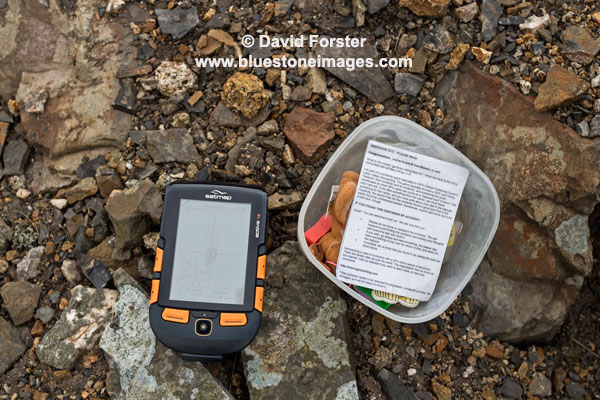
The unit has also been used for the odd Geocache and for road/mountain biking.


Hunting down the odd Geocache was a good way to get to know the unit

In Use
On the whole it is a decent piece of kit, although there are several niggles.

For example in anything bordering on wet weather damp easily gets between screen protector and the screen itself, which obviously affects viewing the unit.  Removing the protective screen is not that easy in the field so you either put up with it, or remove the protector altogether and then risk scratching the screen.  It is not a serious issue as far as reading the mapping goes, but does mean you have to remove the cover at some stage to ensure the screen has dried out.  The unit of course is only weather resistant, not waterproof, but even so if the screen cover joint is hit by a few drops it becomes a problem. It can also be an issue in damp misty conditions as well.  If it bothers you too much then a separate protective case can be purchased at additional cost.

Another associated problem is that dust and other debris can easily get between the screen protector and the screen.  This really hacks me off as I find it distracting in certain light conditions.  Would it really have been so difficult and expensive to add a seal?

The unit comes supplied with a rechargeable battery unit and a separate battery carrier, in which you can add 3AA batteries should the rechargeable battery become discharged.  One of the concerns I have with the plugging and unplugging of each battery pack is that the plug is so tiny you end up pulling on the wires rather than the plug.  It is also rather fiddly and a complete pain when it is cold and windy.  Why a simpler click system, similar to say a camera, or mobile phone was not used I don't know. 

Charging/Download cable
This has a 90-degree bend at the Satmap end of the plug and is of very poor quality and has already split.  I do not incidentally unplug it by pulling on the cable itself. To deal with this I have simply swapped it for a cable with a straight plug.  

On the subject of charging, the unit also switches on and goes through the full boot process when you plug in the charger instead of simply charging the unit.  I got caught out the first time when I simply put the unit away after charging only to find out the battery was flat when I came to use it.     

Having read a number of magazine reviews, many of which appear to have been written quite soon after the release, it amazes me that nobody has mentioned some of these niggles.  Actually no it doesn't, using something for a couple of weeks is not really a review is it.

Unit Operation
The OS mapping software comes on SD card which simply clicks into the side of the unit.  The clarity of the High-Resolution HVGA screen is excellent.  A pal of mine has the  Active10 and there is a clear improvement here. 

Using the large orange buttons to navigate the various menus is pretty straight-forward and fairly intuitive once you understand the terminology.

The unit is also relatively quick to boot up, load mapping from the card and find satellites (average 2-4 minutes).  This does appear to be an improvement when compared to the Active 10 a friend of mine has.

One slight negative is that sometimes the software seems to run very slowly for no identifiable reason and navigating around the map can be frustrating when you move the joystick, but the map hardly scrolls.  Tiling is also quite bad when this happens.  That said I use this unit week in week out and it has not become a serious issue for me.  I assume this will be resolved in future software upgrades.

Testing Limitations
I only use a fraction of the functions available on this unit and therefore cannot comment on such things as paperless geocaching, detailed route planning, barometric elevation, bluetooth and peer-to-peer sharing for example.


My experience of the mapping software is limited to the OS 1:50,000 maps.

I have yet to try updating the software and as I mentioned earlier I did have some serious issues with the upgrade process during beta testing and the unit had to go back twice.  However this was using a different "Light" update process to the Satsync process users now go through and I was assured this would no longer pose a problem. 

In Short
Pros

  • The high res screen also means I don't have to keep putting reading glasses on to see the detail.
  • Orange buttons are easy to see in the dark and fairly easy to use with gloves that are not too bulky
  • Software and mapping fairly straight forward to operate
  • Additional mapping such as OS 1:25K is available on SD cards
  • Rechargeable battery life is good and once discharged it is possible to replace this with 3 AA standard, or Lithium batteries using a separate carrier (supplied with the unit)
  • Compass can be calibrated for use on a bike.
Cons

  • Relatively high cost of unit
  • Additional mapping seems expensive.
  • Changing the battery carrier is a pain due to the tiny plug and you end up pulling on the wires.
  • Screen protector is poorly designed and allows dust, damp and water between it and the screen.
  • Design of the charging/power cable is poor quality and design
  • The unit also switches on and goes through the full boot process when charging instead of simply charging the unit. 

All said I think this is a decent unit and the positives certainly outweigh any negatives.

Rating 4 out of 5


Important information for those new to mountain navigation.
If you are new to walking, especially in a mountain environment, it is important to recognise a GPS unit of any kind is not a replacement for a paper map and compass, along with the ability to navigate using them.

Batteries will discharge quicker in cold weather and you need to carry spares.

If only using the 1:50 mapping software that comes with the unit as standard, a lot of detail such as steep ground and crags for example will not necessarily be obvious.

Regardless of the mapping just like a paper map you still need the ability to read map contours, recognise slope aspect and be able to plan your route, taking into consideration your speed and the fact you may need to navigate around hazards rather than walk on straight A to B bearings to reach your objective.

Text/imagery copyright David Forster www.bluestoneimages.com