Monday 12 August 2019

Wainwright’s - Fellbarrow and Low Fell


From the parking at Waterend we followed the Bridleway opposite towards Miresyke. As we climbed up the views opened out over Loweswater towards Burnbank Fell and Blake Fell, both of which are future Wainwrights for us .


At Myresyke the track headed left left through fields to join with the Mosser Fell Road.

An ancient looking piece of farm machinery in one of the fields

The Mosser Fell main track

This was followed for 700 m or so to a junction where a lane leads rightwards onto Mosser Fell. After the rain of recent days it looked rather wet and boggy so we continued north for around 300 metres until another track on the right offered a way over Mosser Fell towards Fellbarrow.

Once over Mosser beck the surfaced track petered out and became a grassy path. This was followed through an area of bracken and gorse for a short distance onto open fell.

Low Fell on the left and Mellbreak in the centre

The summit soon arrived and offered some nice if rather hazy views north over the Solway Firth to the Scottish mountains of Dumfries and Galloway. 

Approaching the trig on Fellbarrow with the view south towards Burnbank Fell and Blake Fell

The view north into Scotland with the mountain of Criffel in the haze

Following the fence along the undulating broad ridge towards Low Fell we were constantly pestered by Clegs and while I was only bitten a couple of times Moira ended up with half a dozen large weals on her legs, arms and shoulders.

Cleg bite
Incidentally if you are wondering what a Cleg-fly is the pic below is a closeup of one taken from my website. Beautiful eyes but nasty little blighters.

Cleg-Fly (Horse-Fly) Haematopota pluvialis?

This onslaught of these blood sucking little (insert swear word here) took the edge of the wonderful views and we hardly broke step until we reached Sourfoot Fell.

The view from Sourfoot Fell westwards

It was a bit breezier up here and we were left alone to enjoy the views for a few minutes before heading off over Watching Crag.

Crummock Water from the ridge near Watching Crag

Despite the breeze it was very muggy with cloud starting to build over the higher mountains. As a result the views along Crummock Water from the northern and true summit of Low Fell were rather hazy.

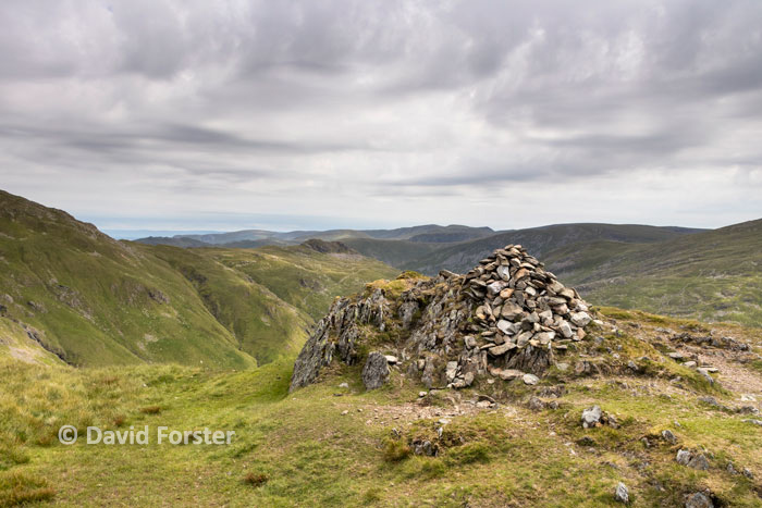
Summit cairn at the northern end of Low Fell

The south top (Wainwright top) of Low Fell from the summit.

On reaching the Wainwright top of Low Fell a few hundred metres to the south we swapped the clegs for clouds of flying ants so retreated from the cairn to sit on a ledge looking out over Crummock Water to have our lunch.

Crummock Water and Mellbreak from the south top

This cairn is a few feet lower and make for a great viewpoint to have our lunch

From Low Fell we made the steep decent down to Crabtree Beck. Having lost all that height we then had to regain most of it via a hot and sweaty trudge up onto Darling Fell.  On top we were rewarded with a raucous welcome from two Ravens sitting on the fence near the summit. 

Seeing this Raven up close made our day

From here we headed down to meet with our upward route on Mosser Fell lane.

That’s 4 nice little fells but only 2 Wainwright’s bagged. This leaves us with 46 to go.

Friday 28 June 2019

Wainwrights - Low Pike and High Pike from Ambleside


From the parking in Ambleside (£7.00 and toilets not open first thing) we (Moira, Graham and Sandra) headed up the Kirkstone road for a few hundred metres before taking a left into Nook Lane.

Under steel grey skies it was hot and muggy as we made our way along the lane leading towards High Sweden Bridge, the oppressive feel of the weather cheered slightly by Foxgloves lining the way.


To start with the views were limited by the high walls of the lane, but a little further along the views opened out westwards over the hay meadows.


High Sweden Bridge is a pleasant spot to stop for a while, however instead of a break by the stream we were keen to get up high in the hope of a breeze, not only to cool us down, but to get rid of the midges which while not in huge numbers, were annoying.

High Sweden Bridge

On the way to Low Pike we passed  through a boggy area that wasn’t really that boggy considering how much rain there has been recently.


The wall was then followed up to the top of Low Pike

High Pike our next objective with the craggy top of Little Hart Crag (right of centre) and our planned descent route back into Scandale from the col to the right.

From here the route up on to High Pike was warm work as the sun began to break through.


Windermere from the top of High Pike

The view NE across Scandale Head towards Little Hart Crag (rocky lump to left of cairn)

The Coniston Fells from just west of the summit wall

Our plan was to head up Thack Bottom Edge to pick up the path to Scandale Tarn before dropping down Scandale pass to meet with our upward route at High Sweden Bridge.

The wall running along Thack Bottom Edge from the summit

Looking ahead we could see the high cairn on High Bakestones so decided to head over and take that in on the way.

Impressive cairn on High Bakestones with Brothers Water just in view to the right

From here it was a pleasant if a little footsore walk down the rocky track back to our start point. On the way we met some rather handsome Highland cattle.


Two more ticked off leaving 48 left to go.

Tuesday 11 June 2019

Wainwright’s - Eagle Crag and Sergeant's Crag


Set between the wonderfully picturesque valleys containing Langstrath Beck and Greenup Gill, these two hills looked like they would make a great days walking.  Eagle Crag also looked like it would offer a bit of adventure in the form of some easy scrambling too.

The only slight worry today was that heavy rain was forecast mid-afternoon and added to last night’s rain we were a bit worried about how greasy the scramble would be and if any streams we had to cross would be doable. In the end we decided to avoid the Lining Crag decent route as this would involve an un-bridged stream crossing and instead do a clockwise walk using the bridges over the lower section of Greenup Gill to access Eagle Crag and then drop down off the north western slopes of Sergeant Crag into Langstrath. 

In the company of Graham and Sandra we made our way in pleasant sunshine along the valley from the Chapel House Farm campsite to Stonethwaite.  Here we used Stonethwaite bridge to get us onto the track on eastern side of the beck. 

Ahead we could see Eagle Crag, which looked impenetrable from this angle.

Eagle Crag with Sergeants Crag just visible to the right

This was followed north east up to Smithymire island to a second bridge at the confluence of Greenup Gill and Langstrath beck.

 Looking back the sunshine was already disappearing and the cloud ceiling dropping.

Stonethwaite Beck from the confluence of Langstath Beck and Greenup Gill
Once across the beck we only followed the path for a few metres before branching off to the left.  Crossing the fence via a stile a rather boggy path led alongside a small wood below Bleak Howe.  After passing through a couple of intake walls we then struck steeply up the eastern flank of Eagle Crag.


The short scramble, while a bit greasy was not a problem and made for a really enjoyable way up.

Traverse above the scrambling
Zigzagging up the final metres to the summit the sky began to look rather oppressive.  This suggested that the rain would arrive well ahead of the forecast.

Sergeants Crag from upper section of Eagle Crag
On top after the obligatory summit pose we had a quick break before heading off towards Sergeant’s Crag.

Borrowdale from the top
By the time we reached its summit the rain was falling and the cloud base was well down.

The summit of Sergeant's Crag 
The craggy nature of the ground to the west meant a direct descent could not be made into Langstrath so we followed the broad ridge south for a km or so towards Brown Crag. Once beyond this we made our way diagonally down steep ground to pick up the Cumbria Way. This was followed for the last leg to the campsite.

Heading down Langstrath on the Cumbria Way

With these 2 hills in the bag we have 50 left to go.

Tuesday 4 June 2019

Wainwright’s - Stone Arthur, Great Rigg, Heron Pike and Nab Scar


I am miles behind with my blogs so just a quick one of our progress.

This walk was done with our friends Graham and Sandra. 

Parking on the A591 we followed Rhododendron lined lane leading up towards Alcock Tarn. This eventually led to a gate giving access to the open fellside.


Here we took the left hand path and made our way steeply up the slopes of Greenhead Gill. The steep nature meant the views soon opened out. 

The view down Greenhead Gill towards Grasmere from part way up the Stone Arthur path
Easier going then took us onto the summit of Stone Arthur.


Grasmere from the summit of Stone Arthur

After a short break the broad ridge was followed up to Great Rigg.

Moira making her way up the final metres to the summit of Great Rigg. 

Our next top was Heron Pike.  This involved a short backtrack so that we could branch off onto the ridge leading to Heron Pike.

The walking here was pleasant and despite being very hazy the views weren’t too bad so we took a quick break on the north top of Heron Pike.

The north top of Heron Pike with the Wainwright summit of Heron Pike ahead
On reaching Heron Pike we only stopped for a quick photo before making our way over Lord Crag and then down towards to Nab Scar

The view towards Windermere from Heron Pike

The achievement of bagging Nab Scar our 4th and final Wainwright of the day was ruined somewhat by an irresponsible dog owner who let their dog run off and chase the sheep. 

Nab Scar
From here another short backtrack took us onto a path that led down to the pretty Alcock Tarn.  
Alcock Tarn


While here we made a short detour to Grey Crag 

Grey Crag and Grasmere
We then headed across to meet with the Greenhead Gill path, Steep going took us down to our start point just as the rain started.

Four more bagged leaving 52 to go.

Friday 31 May 2019

Wainwright’s - Wansfell Pike (Baystones) and Troutbeck Tongue


The weather forecast was not so good with showers and hill cloud the order of the day.  Driving along the shores of Ullswater there was plenty of clear sky to suggest the forecast could to be wrong. Sadly on reaching Kirkstone pass we were met by thick cloud and a heavy drizzle – the forecast was spot on.

Parking just up the road from the Queens Head Hotel on the A592 we walked along the road for a 100m or so and then branched off on the minor road to Troutbeck.

Once in Troutbeck we followed the Nanny Lane track which rose steeply up towards an area marked as the Hundreds on the map.  We were just below the cloud ceiling at this point and it all felt rather claustrophobic as a grey drizzle turned to rain and forced us to don waterproofs.  

Nanny Lane as the rain swept in

On reaching a bend where the track swung north we left the lane and headed across the fellside towards Wansfell Pike.  

Leaving Nanny Lane

The views were limited to a few metres so we just plodded our way towards Wansfell Pike. On the summit the cloud above did seem to be thinning a bit but after hanging around for a while the drizzle returned. 
Approaching Wansfell Pike summit

It is worth mentioning here that while the Wansfell Pike top is accepted (by many) as the top named in the Wainwright’s books. Others however say it the Wainwright is the highest point of the fell just over a kilometre away along the undulating ridge and is marked Baystones on the map.  To add to the confusion the grid ref we had for the Wainwright top was actually a spot height around a 130 metres north of Baystones.  The easy way to solve this was to bag them all as we were heading that way anyway.

After some very soggy going we found the cairn on Baystones . 

Baystones Cairn

After a quick break we headed off to the grid ref we had as Wainwright’s top a little over 100m away. As we did so the cloud began to lift over on Wansfell Pike

Having bagged Wansfell, Baystones and the little lump to the north we felt we had covered all bases so continued our way north towards our next objective Troutdale Tongue.

Looking back to Wansfell Pike as the cloud broke up from the northern end of the ridge

On reaching the end of the walled fields we then dropped off the fell onto the A592 Kirkstone road.

Heading for the Kirkstone Pass road
This was crossed and after a bit of pathless exploration we made away down to the stone slab footbridge over Troutbeck.  

Troutbeck Tongue from just above the stone slab bridge

Slab bridge - a nice pretty spot for a break 


A steep pull then led us onto The Tongue and our second Wainwright.

Troutbeck Tongue with Windermere beyond

The way back

From here we followed the footpath down to Hagg bridge and then followed Ing Lane back to Town Head and our start point. 

 This completes the Far Eastern Fells section, leaving us with 56 to do