Of all the Wainwright’s the Nab was one I wasn’t particularly looking forward to. This is a hill where
access restrictions are in place due to deer management and conservation. Frustratingly despite this being open access
land the walker is discouraged from accessing the fell by any of the shorter approaches/descents. Instead you are expected to access it from the south via boggiest and longest routes possible. When
deer management is taking place (being shot) between September and February then the whole area may even be closed to walkers.
Being outside of the culling season, but still I assume with restrictions in place ,our plan was to climb Beda Fell and
then work our way around the head of the valley via Angle tarn and then access the Nab via the western shoulder of Rest Dodd.
 |
| Sign near the church. |
Parking beside St Martin’s Church, which
unfortunately was locked at this time of a morning, we made our way over
Christy Bridge to take the path leading onto Howstead Brow.
 |
| St Martins Church |
 |
| Christy Bridge with Beda Fell ahead |
 |
| Howe Grain Beck with the View towards the Nab (centre) |
Here there was a handy seat with good views towards Hallin Fell, Gowbarrow Fell and Place Fell, among others.
 |
| Hallin Fell from the Seat on Howstead Brow |
Next we climbed up to Winter Crag.
 |
| Moira on Winter Crag with the view towards the summit of Beda Fell (Beda Head). The summit is just left of centre. The north top is to the right. |
From Winter Crag it was a steady pull up to a prominent cairn which marks the north top of Beda Fell.
 |
| Cairn on the north top and the view west towards Boredale Hause and Fairfield. Place Fell is to the right of the cairn |
The actual summit of the fell at Beda Head is quite a bit further south.
 |
| The summit from the north top. |
The summit soon came and gave us some good views north over Ullswater.
 |
| The summit cairn with Ullswater below and from (L-R) Gowbarrow, Great and Little Mell Fell and Hallin Fell. |
 |
| Ullswater |
From the summit the Nab looked a long way off and considering we
had to make our way around the head of the valley it looked like it would be a
quite an effort, especially so if we had to retrace our steps for a good part
of the way.
For Moira and I being in the hills is not just about
exercise and ticking off summits, we also like to explore a little. In
particular we always keep an eye out for wildlife, or detour to seek out places
with some geological or historical interest.
Some time ago I had read of a plane that had crashed up here during the
Second World War. The aircraft, a Lockheed Hudson MK 5 (Serial Number AM680)
came down here on 10th November 1942 while on a night navigation
exercise.
Initial searches for the aircraft from the air were
unsuccessful due to poor weather, but late the following day the aircraft was found
by searchers on the ground. Sadly none
of the crew, John Frederick Saunders (Pilot), Derric Isaac Jones (Navigator/Air
Bomber), Stanley Alfred Jones (Wireless Operator/Air Gunner) and Harold
Dickinson (Wireless Operator/Air Gunner) survived the crash.
There is no memorial so I doubt many walkers would be
aware of their sacrifice, but as we were to walk within a few hundred metres of
the crash site we decided to stop off and pay our respects.
Not much remains now other than a few small pieces of
aircraft where the aircraft impacted the hillside. If you walk this way perhaps you could spare a few moments to remember to the crew as you pass by.
 |
| Wreckage from the aircraft with the summit behind |
Making our way around the head of the valley we passed Angle
Tarn, but decided to miss out the summits of the nearby Angle Tarn Pikes and
Rest Dodd as we had done these previously.
 |
| Angle Tarn and the view towards Helvellyn and the Dodds |
 |
| Angle Tarn from the slopes of Rest Dodd |
Traversing across to the northern side of Rest Dodd we eventually
found ourselves looking over some very boggy looking peat hags between us and
the Nab.
 |
| The Nab with its peat hags and bogs guarding the way |
This section is notorious for its boggy qualities but fortunately the recent dry weather meant the boggy sections were not too bad and our feet stayed dry. In the heat it was still a bit of a slog to the summit though.
 |
| The summit of the Nab with Beda Fell and the Helvellyn range beyond |
 |
| Happy |
To get back down it was a choice of either retracing our steps all the way back up to Rest Dodd and then around the head of the valley, or a much easier and rather more pleasing route down the open access land to the valley floor.
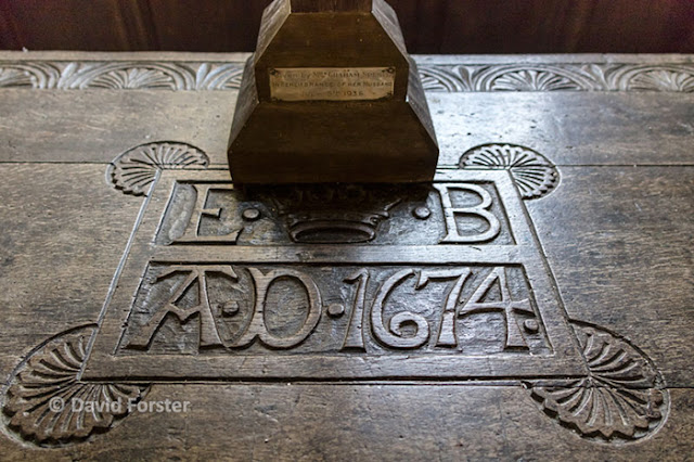
Back at the car we had a look around the old church and then
headed outside to look at the ancient Yew tree which is thought to be at least
1300 years old.
 |
| Carved altar table |
 |
The ancient Yew with the tomb of Richard Birkett who was the
first priest of St Martin’s in its shade
All in all a cracking walk, even if we did not see a single deer all day!.
That leaves 63 left to do.


No comments:
Post a Comment